Blue Water Trail
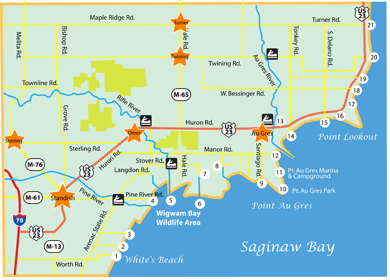
Locations Along the Arenac Blue Water Trail
- End of Worth Rd. & White's Beach Rd.
- End of Bordeau Rd. & Standish Nature Preserve
- End of Sagatoo Rd. & Eagle Bay MarinaThe Arenac Water Trail
- Wigwam Bay Pine River Access
- Rifle River Mouth
- End of Stover Rd.
- End of Big Creek Rd.
- End of Dreyer Rd.
- End of Santiago Rd.
- Pt. Au Gres Park
- Pt. Au Gres Marina & Campground
- DNR Public Access
- Au Gres City Park
- End of S. Tonkey Rd.
- End of S. Delano Rd.
- End of Foster Rd.
- Sims-Whitney Cemetery
- End of W. Bessinger Rd.
- End of Hammel Beach Rd.
- End of Twining Rd.
- End of Turner Rd. & "The Singing Bridge"
Arenac Blue Water Trail Map
The Arenac Blue Water Trail Project
The Arenac County Blue Water Trail is a project begun in 2013 to provide kayakers and canoeists access to the many waterfowl and wildlife viewing experiences along the northern coastline of Saginaw Bay. Arenac is birding paradise, and along with a myriad of different types of waterfowl nesting here and in migration you can also spot Buntings, Eagles, Kittiwakes, Goshawks, Kestrels, Woodpeckers, and Yellowthroat. It is also host to many species of freshwater fish including walleye, lake trout, steelhead, suckers, and bass, so bring your fishing rod.
The water trail is currently a work in progress, so it is primarily a wilderness experience and should be treated as one. Arenac County has a vast shoreline with few if any amenities, and very limited access at the various road endings. Be sure to plan your trip carefully and bring accurate maps. Day trips are recommended at first to become familiar with the shoreline before planning extended overnight excursions. Remember that just like backpacking into the wilderness, you will need to pack out all of your trash. There also are no bathroom facilities along the trail except at the parks and commercial marinas.
Safety first! Be aware that storms on the Great Lakes can come up quickly. Prepare yourself to allow enough time to get to shore and set up a shelter in the event of a storm. There is a real possibility you may need to stay overnight.
There are various marinas along the shore where you can put in and also get supplies. It is best to check out their locations before you get on the water. The campgrounds listed below are a great place to begin.
Number 10 on the map: Point Au Gres Park, 3177 S. Rumsey Road, Au Gres
Point Au Gres Park is considered to be the primary launch site for the Blue Water Trail. Located right on the shoreline on Rumsey Road south of Au Gres, the facility includes 5 rental cabins and 16 campsites (7 w/electric & water, 9 rustic) along with a day-use park with picnic tables, grills, volleyball, horseshoes and 900' of sandy beachfront. It is a great place to make camp and begin your journey. Click HERE for reservations.
Number 13 on the map: Au Gres City Park & Riverfront Campground, N Main Street, Au Gres
The Au Gres City Riverfront Park has 109 campsites available for daily, weekly, monthly or seasonal rates. Facilities include tennis courts, basketball courts, volleyball court, baseball/softball fields, shuffleboard, horseshoes, and children's playground and lighted riverfront walkway. Call (989) 876-8310 or reservations can be made online at www.cityofau-gres-mi.org
Recommended Supplies:
- Waterproof pack for camera and mobile phone
- Tent & sleeping bag
- Dry bag with an extra change of clothes
- Drinking water
- Sunscreen
- Sunglasses
- Insect repellant
- Bag for trash removal
Reminders:
Check the weather in advance, especially the wind direction.
Personal flotation devices are required by law. Please visit the U.S. Coast Guard Auxiliary website for all items required for Great Lakes recreational boating: (www.cgaux.org).
Plan to carry all trash out with you and dispose of all waste materials appropriately.